


คำอธิบายของ Polaris GPS Navigation: Hiking, Marine, Offroad
Easy-to-use high performance GPS for wherever your travels take you. No account setup or subscriptions required.
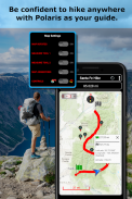
Turn your phone into a powerful GPS navigation system with Polaris Navigation GPS, the world's #1 all-purpose GPS, and dare to go where there are no roads.
Imagine... What would it be like to navigate any waterway or explore any wilderness or city using only your phone's GPS location abilities and a view of the sky? What it would be like to create navigation destinations without the need of an internet connection and find them using only an arrow or offline maps.
That is just a glimpse of the navigational power you will hold in your hands when you install Polaris Navigation GPS.
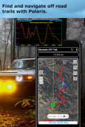
Used mostly as a hiking, off road, nautical and trail GPS app, Polaris is an excellent backup or replacement for your handheld dedicated GPS satellite navigation unit and will keep you oriented wherever your outdoor adventures take you!
Typical usage:
● Hiking GPS with the best hiking maps!
● Back country exploration and outdoor adventure
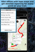
● Trail recorder
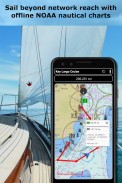
● Sailing, Boating. All marine navigation charts in Polaris are free.
● Fishing GPS. Find you favorite fishing hole.
● Hunting and hunting maps. Find you favorite hunting blind and your way back!
● Geocache
● Camping
● Mountain Biking and bike maps
● Backpacking and other outdoor sports
● Compass orienteering
Known for its stability, reliability and flexibility, Polaris is used by land-sea search and rescue, military personnel and millions of others worldwide.
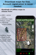
To support your offline adventures we provide free of charge:
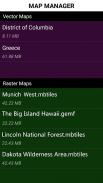
📡 Access to our vector & raster map downloaders (topos, marine, hiking and others).
📡 No limits on map types or on the number of map downloads.
📡 All maps are shown with high detail and large, easy to read labels.
This powerful navigation system also includes:
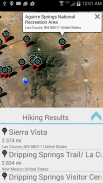
📡 Polaris Places Picker. Find hiking trails, camping locations and much more!
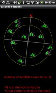
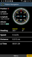
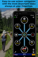
📡 GPS compass and magnetic compass
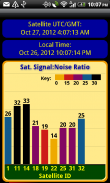
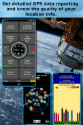
📡 GPS parameters panel
📡 Odometers, altimeters, speedometers, chronometers
📡 Split distances on tracks
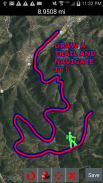
📡 Draw a trail and navigate it
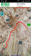
📡 Google Maps, OpenStreetMap-Mapnik, Topographic Maps, Cycle Route and Hiking Maps, Vector Maps, USGS Topo Maps, NOAA Marine Charts, World Aviation Operations Charts, Canada Toporama.
📡 Comprehensive set of GPS Tools and diagnostics
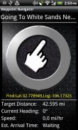
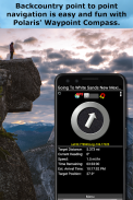
📡 Waypoint navigation system including a dynamic waypoint-finding compass that always points to your destination while reporting estimated time of arrival, distance to target and other statistics. Just follow the arrow!
📡 Trail navigation system
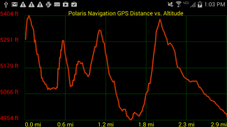
📡 Altitude profiles
📡 Location sharing
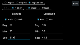
📡 Supports British OSGR and OSGB-36 DATUM (Ordnance Survey Grid)
📡 Coordinate formats: latitude/longitude as degrees, deg:min, deg:min:sec, and UTM (Universal Transverse Mercator).
📡 Military Coordinate Finder - Military Grid Coordinate Reference System (MGRS).
📡 Hiking Trails - Most of the maps show hiking paths courtesy of the Openstreetmap project. We are always amazed to find that even some of the most obscure hiking routes in our state are available.
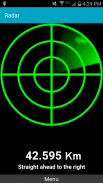
⚓ Marine navigation- NOAA Nautical Charts and nautical unit reporting.
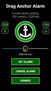
⚓ Drift alert / Drag anchor alarm.
📡 Select source for altitude reporting: Satellites, United States Geologic Survey or map your location to the results of NASA's Space Shuttle Radar Topography Mission
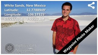
📡 Waypoint photography.
📡Map Search and Coordinate Conversion capabilities with the free MapIt! plug-in
📡 Improved compatibility for maritime navigation with addition of nautical and NOAA marine charts.
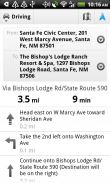
📡 Road navigation and street directions are provided through a digital pipeline connecting the power of Polaris to the Google Maps app on your device.
* The premium version of Polaris Navigation is called GPS Waypoints Navigator, available on Google Play. GPS Waypoints Navigator is ad-free and contains many other enhancements.
GPS ประสิทธิภาพสูงใช้งานง่ายไม่ว่าคุณจะเดินทางไปที่ใด ไม่จำเป็นต้องตั้งค่าบัญชีหรือสมัครสมาชิก
เปลี่ยนโทรศัพท์ของคุณให้เป็นระบบนำทาง GPS ที่ทรงพลังด้วย Polaris Navigation GPS, GPS อเนกประสงค์อันดับ 1 ของโลกและกล้าที่จะไปในที่ที่ไม่มีถนน
ลองนึกภาพ ... จะเป็นยังไงที่จะสำรวจเส้นทางน้ำหรือสำรวจความเป็นป่าหรือเมืองใด ๆ โดยใช้ความสามารถตำแหน่ง GPS ในโทรศัพท์ของคุณและมุมมองท้องฟ้า? สิ่งที่ต้องการสร้างการนำทางปลายทางโดยไม่จำเป็นต้องเชื่อมต่ออินเทอร์เน็ตและค้นหาโดยใช้เพียงลูกศรหรือแผนที่ออฟไลน์
นั่นเป็นเพียงแวบหนึ่งของพลังการเดินเรือที่คุณจะถืออยู่ในมือของคุณเมื่อคุณติดตั้ง Polaris Navigation GPS
ส่วนใหญ่ใช้เป็นไต่เขาออฟโรดทะเลและเส้นทาง GPS แอพ Polaris เป็นการสำรองหรือทดแทนที่ยอดเยี่ยมสำหรับหน่วยนำทางด้วยดาวเทียม GPS สำหรับมือถือโดยเฉพาะและจะทำให้คุณมุ่งเน้นทุกการผจญภัยกลางแจ้งของคุณ!
การใช้งานทั่วไป:
●ไต่เขา GPS ด้วยแผนที่เดินป่าที่ดีที่สุด!
●การสำรวจประเทศด้านหลังและการผจญภัยกลางแจ้ง
●เครื่องบันทึกเส้นทาง
●เรือใบพายเรือ แผนภูมินำทางทางทะเลทั้งหมดใน Polaris นั้นฟรี
●จีพีเอสตกปลา ค้นหาหลุมตกปลาที่คุณชื่นชอบ
●การล่าสัตว์และแผนที่การล่าสัตว์ หาคนตาบอดที่ชอบล่าสัตว์และกลับมาแล้ว!
● Geocache
●แคมป์ปิ้ง
●แผนที่ปั่นจักรยานเสือภูเขาและจักรยาน
●แบกเป้และกีฬากลางแจ้งอื่น ๆ
●เข็มทิศปรับทิศทาง
Polaris เป็นที่รู้จักในนาม เสถียรภาพความน่าเชื่อถือและความยืดหยุ่น โดยใช้การค้นหาและช่วยเหลือทางบกเจ้าหน้าที่ทหารและอีกหลายล้านคนทั่วโลก
เพื่อสนับสนุนการผจญภัยออฟไลน์ของคุณเราให้บริการฟรี:
📡เข้าถึงเครื่องมือดาวน์โหลดแผนที่แบบเวกเตอร์ & แรสเตอร์ของเรา (topos, Marine, Hiking และอื่น ๆ )
📡ไม่ จำกัด ประเภทแผนที่หรือจำนวนดาวน์โหลดแผนที่
maps แผนที่ทั้งหมดจะแสดงด้วยรายละเอียดสูงและป้ายกำกับขนาดใหญ่อ่านง่าย
ระบบนำทางที่ทรงพลังนี้ยังรวมถึง:
📡ตัวเลือกสถานที่ Polaris ค้นหาเส้นทางเดินป่าสถานที่ตั้งแคมป์และอีกมากมาย!
📡เข็มทิศ GPS และเข็มทิศแม่เหล็ก
panel แผงพารามิเตอร์ GPS
📡เครื่องวัดระยะทาง, เครื่องวัดความสูง, เครื่องวัดความเร็ว, เครื่องวัดความเร็ว
📡แยกระยะทางบนรางรถไฟ
📡วาดเส้นทางและนำทาง
📡 Google Maps, OpenStreetMap-Mapnik, แผนที่ภูมิประเทศ, เส้นทางจักรยานและแผนที่การปีนเขา, แผนที่เวกเตอร์, USGS Topo Maps, แผนที่ NOAA Marine Charts, แผนที่ปฏิบัติการการบินโลก, แคนาดา Toporama
set ชุดเครื่องมือ GPS และการวินิจฉัยที่ครอบคลุม
navigation ระบบนำทาง Waypoint รวมถึงเข็มทิศค้นหาจุดพลวัตที่มักจะชี้ไปยังปลายทางของคุณในขณะที่รายงานเวลาที่คาดว่าจะมาถึงระยะทางไปยังเป้าหมายและสถิติอื่น ๆ เพียงทำตามลูกศร!
navigation ระบบนำทาง
profiles โปรไฟล์ระดับความสูง
sharing การแชร์ตำแหน่ง
📡รองรับ British OSGR และ OSGB-36 DATUM (กริดสรรพาวุธ)
formats รูปแบบพิกัด: ละติจูด / ลองจิจูดเป็นองศา, deg: min, deg: min: sec, และ UTM (Universal Transverse Mercator)
Finder เครื่องมือค้นหาพิกัดพิกัดทางทหาร - ตารางอ้างอิงระบบพิกัดทหาร (MGRS)
📡เส้นทางเดินป่า - แผนที่ส่วนใหญ่แสดงเส้นทางเดินป่าซึ่งได้รับความอนุเคราะห์จากโครงการ Openstreetmap เราประหลาดใจเสมอที่พบว่าแม้แต่เส้นทางเดินป่าที่คลุมเครือที่สุดในรัฐของเราก็ยังมีให้บริการ
navigation การนำทางทะเล - แผนที่เดินเรือ NOAA และการรายงานหน่วยเดินเรือ
⚓การแจ้งเตือนดริฟท์ / ลากการเตือนสมอ
source เลือกแหล่งที่มาสำหรับการรายงานระดับความสูง: ดาวเทียมการสำรวจธรณีวิทยาของสหรัฐอเมริกาหรือทำแผนที่ที่ตั้งของคุณไปยังผลลัพธ์ของภารกิจกระสวยเรดาร์เรดาร์ภูมิประเทศของนาซ่า
📡การถ่ายภาพ Waypoint
📡แผนที่ความสามารถในการค้นหาและประสานงานการแปลงด้วย MapIt ฟรี! เสียบเข้าไป
compatibility ปรับปรุงความเข้ากันได้สำหรับการนำทางทะเลด้วยการเพิ่มแผนภูมิทางทะเลและ NOAA
navigation การนำทางถนนและเส้นทางถนนผ่านท่อดิจิตอลที่เชื่อมต่อพลังของ Polaris ไปยังแอป Google Maps บนอุปกรณ์ของคุณ
* Polaris Navigation รุ่นพรีเมี่ยมเรียกว่า GPS Waypoints Navigator มีอยู่ใน Google Play GPS Waypoints Navigator ไม่มีโฆษณาและมีการปรับปรุงอื่น ๆ อีกมากมาย
Polaris GPS Navigation: Hiking, Marine, Offroad--เวอร์ชั่น9.25
(30-01-2024)
Polaris GPS Navigation: Hiking, Marine, Offroad - ข้อมูล APK
เวอร์ชั่น APK: 9.25แพ็คเกจ: com.discipleskies.android.polarisnavigationเวอร์ชั่นล่าสุดของPolaris GPS Navigation: Hiking, Marine, Offroad
แอปในประเภทเดียวกัน
คุณอาจจะชอบ...


